NJ TRANSIT’s marketing image (top) shows customers how they can use the agency’s MyTix® app to purchase tickets for their transit trips. TransitScreen® (bottom-left) provides real time information. MTA offers BusTime® (bottom right). Sources: NJTRANSIT; TransitScreen®; Marc A. Hermann / MTA New York City Transit
.jpg)
Imagine you’re a young professional. You live in an up-and-coming community that has worked hard to develop the area around its train station and main bus stop. Today, you’re sitting in a coffee shop working hurriedly on your laptop to fine-tune a proposal. You also need to get to an important client meeting that starts in 30 minutes.

You have carefully planned your trip: take the bus from the stop on the corner, then hop on a bikeshare bike and ride to your client’s office. The perils are many. The bus is coming in five minutes and you haven’t quite finished the proposal. What if you miss the bus? What if the bus is late? What if you miss your stop? What if the bikeshare dock is out of bikes?
You could skip all this trouble by taking a rideshare, but you really need Wi-Fi.
Fortunately, you have a trip planning app. It tells you when you can expect the bus to arrive and will alert you when it is approaching. It also tells you that there are plenty of bikes left at the dock near the destination bus stop, and that it will be a five-minute bike ride and then a one-minute walk from the dock located around the corner from your client’s office. And your proposal? Well, the bus is equipped with Wi-Fi, so you’ll be able to submit it online on the way to the meeting!
It may have seemed like a pipe-dream just a few years ago, but all the mobility options and tools our hypothetical young professional just used are now increasingly available.
The rise of tech-driven mobility presents important opportunities for TOD. A strong TOD community offers not only a variety of amenities close at hand, but also a range of mobility options that suit different users and trip purposes. Tech has made transit more convenient while also opening up a whole new world of flexible mobility options that address a key transit challenge—transportation to and from the transit station or stop, also known as the first-mile/last-mile problem.
A Rough Start
Tech-driven mobility is largely driven by the private sector. Despite often adversarial relationships with local governments in the past, Transportation Network Companies (TNCs), such as Lyft and Uber, have recently shifted their business model to focus on larger mobility issues and identify opportunities for cooperation with governments and transit agencies.
The ride-hailing services provided by TNCs—on-demand rides ordered through an app—have become an important part of the TOD mobility option mix, though the app-driven services have also brought with them significant challenges for local communities, including additional congestion caused by circulating ride-hailing drivers and haphazard pick-ups and drop-offs. There is also mounting evidence that some passengers are abandoning trains and buses for the convenience of rideshare.
According to a 2017 UC Davis study, ride-hailing contributes to growth in vehicle miles traveled by attracting people away from transit, walking, and biking and encouraging people to take trips they otherwise wouldn’t have taken. In addition, most ride-hailing trips are private rides (for only one passenger). A study by the Boston Area Metropolitan Area Planning Council estimates that in 2017, the region’s transit provider lost approximately $19.3 million in revenue “as a direct result of ride-hailing.”
However, the UC Davis study also found that ride-hailing serves a complementary role for commuter rail.
Local and state attempts at regulation have resulted in a number of high-profile and heated legal and political battles in Austin, New York, San Francisco, Seattle, and elsewhere. These have been fought out in the media, in courtrooms, and at the ballot box. While local and state governments have generally succeeded in imposing general safety regulations, such as driver background checks, others have gone further. A 10-cent per-ride tax on rideshare has been implemented in Massachusetts, and caps have been placed on the number of ride-hailing vehicles in New York City.
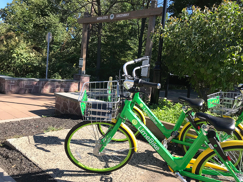
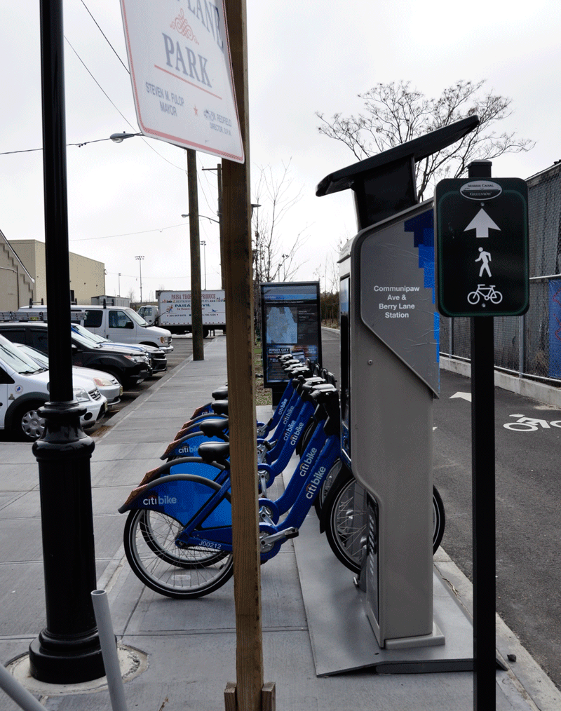
More recently, “micromobility” options have been added into the mobility mix. These include dockless bikeshare and electric bikes and scooters. Dockless bike-share systems do not have designated docks where users pick up and drop off their bikes. Instead, dockless systems use GPS and smartphone apps that allow users to locate bikes wherever they have been left. These systems can offer both regular bikes and e-bikes, which give riders a motorized assist when they pedal. Electric scooter services work similarly, as users can locate and unlock scooters with an app and leave scooters on the sidewalk when they reach their destination.
Like ridesharing, micromobility options offer a convenient first-mile/last-mile solution, but cities hosting these services must grapple with the accompanying challenges, such as safety and curbside management. Learning from their experience with ride-hailing services, many cities, such as Washington, D.C., have been more deliberate when allowing dockless bikes and e-scooters onto their streets. Likewise, micromobility providers have taken a more collaborative approach with city governments.
TNCs Go Multi-Modal
Amid the fallout from battles with local and state governments, TNCs have shifted gears, rebranding their services as multi-modal platforms with the goals of reducing private automobile use and congestion and encouraging transit.

In a September 2018 blog post, Uber CEO Dara Khosrowshahi outlined the company’s commitments to work with the private and public sector and invest financial resources to solve transportation problems. “Today, we’re at an inflection point,” Khosrowshahi writes. “The private and public sectors need to come together and collaborate on ways to create smarter, safer and more efficient ways of getting people from A to B.”
Action has accompanied these rebranding efforts. Uber and Lyft have both entered the micromobility market. In 2018, Uber acquired the dockless bikeshare company Jump, which now offers e-scooters as well. Uber recently added an option to its app that lets users toggle between choosing a traditional ride-hailing option or choosing bikes or scooters. Lyft has also launched e-scooter and bike-share services and revamped its app to encourage shared rides.
Today, we’re at an inflection point. The private and public sectors need to come together and collaborate on ways to create smarter, safer and more efficient ways of getting people from A to B.” ~ Dara Khosrowshahi, Uber CEO
To better integrate services with local transit, Lyft’s app now includes information about transit stops with real-time arrival information, and Uber launched a pilot app feature in Denver with the same capabilities. Eventually the pilot feature will allow users to pay transit boarding fees with their phones. Several transit agencies, including Dallas’ DART, have partnered with TNCs to allow customers to order a ride-share using the transit agency’s mobile app.
Early Successes
Even before the recent transition to “everything mobility,” TNCs had started collaborating with public partners to achieve a number of local objectives. Many of these collaborations attempt to tap into ride-hailing’s potential to complement, rather than substitute for, transit and to meet the needs of people with mobility challenges.
A 2018 DePaul University study inventories 29 partnerships between TNCs and public bodies around the US. According to the study, the most common motivation for pursuing partnerships is to cover gaps in areas where transit services are limited or nonexistent and to reduce parking demand.
One such program is located in New Jersey. The City of Summit in Union County partners with Lyft to allow residents with a station parking pass to get a ride to and from the Summit Station for the same cost as a daily parking fee. The program was the first of its kind in the US when it was launched in 2016 with Uber as the service provider. The City switched to Lyft after the results of a survey indicated users would use the service more frequently if they could schedule rides in advance, a preference that Lyft accommodated.
Other agencies also use ride-hailing to encourage transit use. The Southeastern Pennsylvania Public Transit Authority (SEPTA), which serves metropolitan Philadelphia, conducted a pilot program with Uber that provided commuters with discounts of up to 40 percent when traveling to or from 11 rail stations that have limited feeder bus service or parking shortages. However, the Philadelphia area program was discontinued partially because there was not enough data available to evaluate performance. This unfortunate example illustrates the importance of having access to ride-hailing data.
Accessibility to ridesharing services for people with disabilities has been a source of contention. New York Lawyers for the Public Interest assessed the quality of wheelchair-accessible vehicle (WAV) services by ordering WAV and non-WAV rides. They found that 70 percent of the time, there were no available WAVs, and when a WAV was located, there were major disparities between WAV and non-WAV wait times. A number of lawsuits have been brought against Uber and Lyft by accessibility advocates.
However, many communities have partnered with TNCs to address the needs of people with significant mobility challenges. Uber launched a major partnership with paratransit provider MV Transit in six U.S. and Canadian cities to provide pickups for riders using wheelchairs in 15 minutes or less through the Uber app.
In New Jersey, EZ Ride, a Transportation Management Association (TMA) serving Bergen, Monmouth, and parts of Essex and Passaic Counties, provides rides through Ryde4Life, a membership-based transportation program that coordinates ride-hailing services for older adults and people with disabilities. EZ Ride partnered with the City of Asbury Park and the Alliance for a Healthier Asbury Park to launch Ride4Life-Asbury Park. Qualified riders pay half the cost of a ride for medical or grocery trips within a ten-mile radius, for up to eight trips per month. Participants without a smartphone can call an EZ Ride Coordinator to request a ride.
These programs demonstrate how ride-hailing can become a part of the TOD mobility mix. But there are many instances in which communities have used ride-sharing as a replacement for transit. Communities such as Pinellas Park, FL, San Clemente, CA, and Dayton, OH have partnered with TNCs to provide discounted rideshares along cancelled bus routes. Other communities, such as Altamonte Springs, FL, provide municipality-wide discounts on ride-hailing trips. These programs have led to concerns that the congestion and pollution reduction benefits of transit are being sacrificed in the name of cost savings and that the potential of ride-hailing to boost transit ridership is ignored.
Mobility in Your Pocket: Wi-Fi, Trip Planning Apps, and Parking Apps
Uber and Lyft are relatively new to the inter-modal planning app scene. A proliferation of transit planning apps in the past few years has been driven by the development of the General Transit Feed Specification (GTFS). First developed in the mid-2000s, GTFS has become a standard format for exchanging public transportation data, including routes, schedules and fare information.
Entrepreneurial companies have used GTFS published by transit agencies and real-time data feeds to fill in gaps left by traditional trip planning apps like Google Maps, Waze or Mapquest. Mobility apps let users plan routes, compare different modes, and plan connections between different transit agencies and even between different modes (which include ride-share and micromobility options).
Moovit, Citymapper, and Transit: Real-Time Transit App are some of the more popular intermodal trip planning apps. These apps provide real-time arrival updates using GPS trackers installed on transit vehicles to determine location and data driven estimates to predict arrival time. They also give users step-by-step instructions for taking transit, including transfer information and “get-off” alerts, and provide real-time alerts on transit delays, traffic jams and other issues along the route. All three apps provide information on NJ TRANSIT bus and rail.
Citymapper and Transit app provide real-time bikeshare information, including dock location and the number of bikes available for certain providers. Citymapper directs users to the best pick up spots for Uber or Lyft. Transit combines the functions of several other apps; it lets users pay for bikeshare passes and unlock bikes in select cities, check arrival times for the closest rideshare vehicles, and even request a ride. This “Transit+” approach is based on the premise that many trips can be made faster by combining transit with rideshare.
Many transit agencies around the country provide apps specific to their own system, such as RidePath, My PATCO, My Transit NYC Subway, Bus, Rail (MTA), and Map & Navigation (SEPTA). LACMTA’s (Los Angeles) Go Metro app provides a trip planner with information from 24 carriers operating in the region and can be used to plan trips that use different modes, including rail, bus, bike, park & ride, and walking.
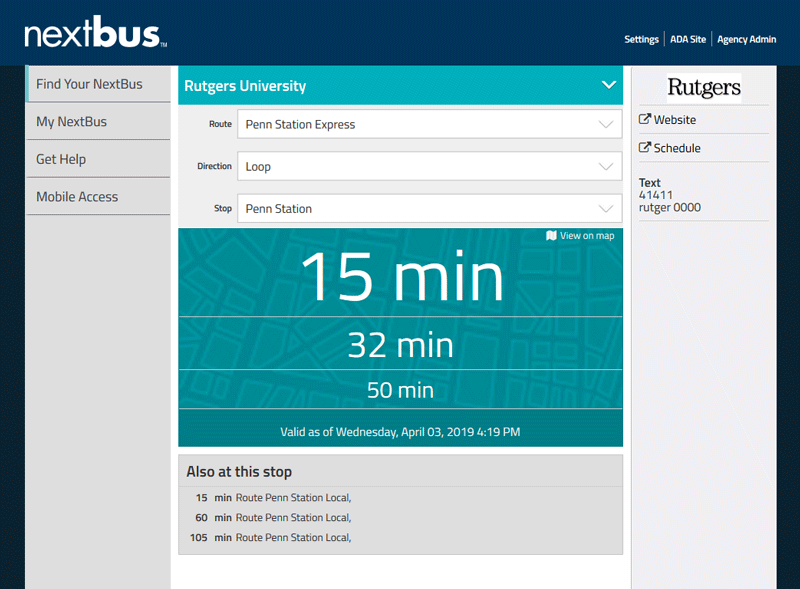
The NJ TRANSIT Mobile App provides transit alert notifications, location-to-location schedules, and real-time train (Departure Vision) and bus (MyBus) arrival times using GPS devices installed on the vehicles. The smartphone version of the Trip Planner feature does not map routes, but suggests rail, light rail and bus options for travel to a final destination, with information about walking distances between connections. Several apps are available for the Rutgers University bus system that display bus arrival times, show live maps of bus routes, and provide directions for the fastest routes between stops.
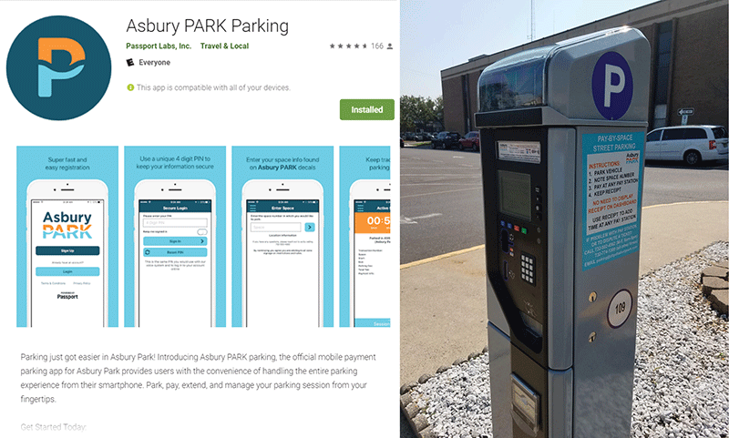
TOD communities must manage the circulation of vehicular traffic, and that includes parking. Studies have shown that a significant percentage of congestion is due to motorists cruising for a parking space. Here, too, technology provides potential solutions. For participating facilities and locations, apps such as ParkMobile allow users to reserve spaces and pay for and extend parking, and show which areas of a city have available spots. Asbury Park implemented its use of smart parking meters in conjunction with the Asbury Park Parking app, which lets users pay for parking, track remaining time, and extend the session. The City also uses data from the meter and the app to inform pricing adjustments to manage parking demand.
Free Wi-Fi service in transit stations is now common across the country, though less so onboard vehicles. NJ TRANSIT partners with internet service provider Optimum to provide high-speed Wi-Fi access at about 80 rail stations, with plans to expand the service to other stations. Some transit agencies have introduced Wi-Fi on vehicles. New York City Metropolitan Transit Authority (MTA) rolled out new buses serving local routes with Wi-Fi service and USB charging ports in 2017 and upgraded existing buses to have the same features. Rutgers University installed Wi-Fi on its buses in 2018.
Better Travel through Smarter Buildings, Transit & Cities
A smartphone, however, doesn’t provide all the information a transit user might need. Despite the growth of app-enabled mobility solutions, TOD communities must continue to serve the mobility needs of people who do not have (or cannot use) smartphones or who do not have access to other online capabilities.
According to the Pew Research Center, about 77 percent of Americans own a smartphone, but ownership varies widely among demographic groups. Perhaps unsurprisingly, young adults report the highest levels of ownership at 94 percent. But while smartphone use among older Americans has been growing rapidly, only 46 percent of people 65 or older report owning a smartphone. Additionally the cost of buying and using a smartphone can be a burden for many people, regardless of age. Only about two out of every three people earning less than $30,000 a year own a smartphone.
But technology still offers ways to improve services and experiences for those not using a smartphone. Smart kiosks, interactive screens, and other forms of electronic display provide the same services offered through personal apps. Building lobbies and elevators, on-street kiosks, and bus stops and stations are being equipped with these devices, easing travel for daily commuters and area newcomers alike.
Services such as TransitScreen® offer software that combines real time information from multiple transportation providers (such as transit, TNCs, carshare, bikeshare, and micromobility options), news about local events, and advertisements of local businesses and attractions. Displays with data from TransitScreen or other providers are growing in popularity and can be seen in multifamily dwellings, commercial offices, universities, and airports. Additionally, TransitScreen offers its Mobility Score®. Akin to Walk Score®, this service provides an easy-to-understand measure of transportation access that evaluates access to public transit, carsharing, bikesharing, and hailed ridesharing services, and rates how easy it is to get around.
Several transit agencies have adopted the use of interactive displays to deliver real-time information at their stations and stops. The On the Go Travel Station Network is the MTA’s system of interactive kiosks, implemented through a public-private partnership between the agency, OUTFRONT Media (formerly CBS Outdoor) and Intersection (formerly Control Group). Riders can gain information about service status, plan their trip, and learn about local destinations using touch-sensitive screens that are now located at more than 30 subway stations. The design of the interface focused on the needs of three travel “archetypes:” locals, commuters, and tourists. The display design is optimized to serve the needs of those with reduced mobility by providing an adaptive user experience, and provides information about the location and status of escalators and elevators throughout the MTA system.
Other transit providers, including Chicago Transit Authority (CTA) and SEPTA, have worked with Intersection to add real-time signage and information kiosks throughout their systems. In December 2018, NJ TRANSIT approved a contract to add similar devices and content to their facilities.
Text-Tech (or How “Lower-Tech” Solutions are Still Tech Solutions)
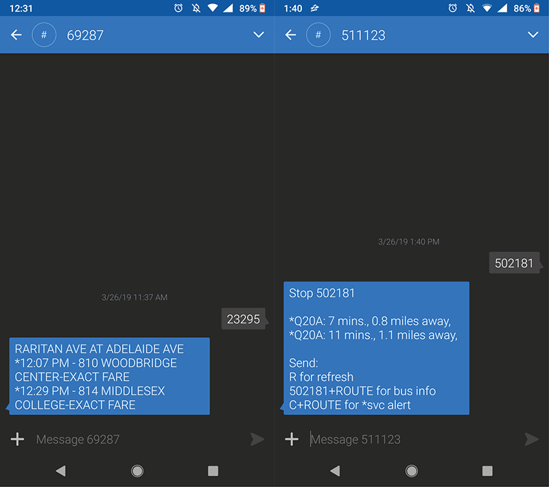
Still other less sophisticated technologies continue to serve users well. For example, SMS services such as NJ TRANSIT’s MyBus (69287) provide bus schedule information via text. Similarly MTA Bus Time (511123), and TextMarks (41411), a private text messaging service used by SEPTA, other transit agencies, and other industries, provide real-time transit information. With any of these services, users send a text with a transit stop ID number (or agency name and stop ID) and receive information back by text. IDs can be found at the stop or via the web.
Text-based services like these illustrate ways that transit providers seek to serve all customers. Agencies also continue to provide paper schedules and route maps (brochures and posters at stations), including versions geared toward the visually impaired.
The Future, There’s an App for That
Transit and inter-modal apps solve many problems facing the transit rider, but they cannot make buses and trains arrive on time or ensure passengers enjoy a safe and comfortable ride. The success of the transit system serving a TOD community will continue to depend on the basic and timeless factors of transit viability—reliability and quality of service. It is increasingly clear, however, that the brave new world of technology is becoming an indispensable element of the TOD and transit-riding experience.
For agencies and communities on the cutting edge, helping travelers to seamlessly ride across multiple systems and modes is crucial. The newest apps are looking to manage payments to multiple transit systems and use predictive analytics to provide users information that goes beyond schedule and arrival times. For those interested in TOD—communities, transit providers, planners, and developers, to name a few—there is an increasing sense of urgency to think about how a tech-filled future will shape and be shaped by users’ needs and how technology can enhance TOD. We all know that technology holds a great deal of promise, but now is the time to consider how it helps people live in ways they want to live.