
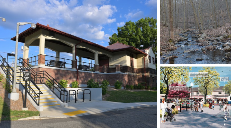
Left: Renovated Mahwah Station (4300streetcar | Wikimedia), Top Right: MacMillan Brook in Mahwah (Ryan Hodnett |Wikimedia), Bottom Right: Potential placemaking and mobility improvements at Veterans Square at Mahwah (NJ TRANSIT)


The times are a-changing and with those changes, the Bergen County Township of Mahwah is looking to adapt to meet the needs of its residents. Known for its extensive open space, suburban neighborhoods, and location at the northern edge of New Jersey’s rail network, Mahwah faces a challenge familiar to many communities across the state: how to accommodate changing housing and transportation needs while preserving the qualities and character that residents value.
NJ TRANSIT’s Transit Friendly Planning team recently partnered with the Township to explore one possible answer. The Mahwah Station TOD Study examines how the area surrounding Mahwah Station could evolve into a more vibrant, walkable district that expands mobility options, supports local businesses, and creates new opportunities for housing and community life.
With more than half of the municipality preserved as open space, opportunities for future development are limited. Rather than expanding outward, the study focuses on how strategic redevelopment and investment around the station could help accommodate future needs while directing growth to an area already served by infrastructure and transit. The result is a vision that balances growth with preservation, strengthening both the station and the community around it.
Why Plan for Growth Around the Station?
Although Mahwah’s population has remained relatively stable at about 25,000 for more than a decade, the community’s housing needs are changing (U.S. Census Bureau, n.d.-a). Between 2010 and 2023, the township’s median age increased by seven years, and the number of households with at least one resident over age 65 rose by 58 percent (NJ TRANSIT, 2025). These trends point to growing demand for housing options that allow residents to remain in the community as they age.
At the same time, housing affordability has become an increasing concern for some residents. The number of renter-occupied units increased by 19 percent during the same period, and nearly 52 percent of renters were cost-burdened (NJ TRANSIT, 2025). Together, these changes suggest a need for a wider range of housing choices in a township with a housing stock that is primarily single-family.
For Mahwah, the station area presents an opportunity to respond to those evolving needs. Concentrating housing, services, and transportation investments near transit can help accommodate future growth while protecting the natural resources and open spaces that define the township.
From Train Station to Community Hub
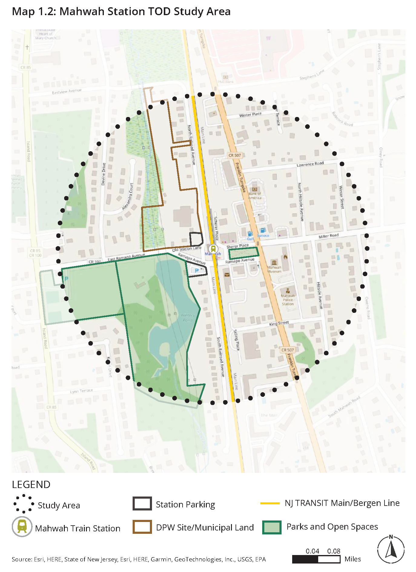
For many residents, Mahwah Station is primarily a place to catch a train. The TOD study envisions it becoming something more: a community hub where housing, businesses, public spaces, and transportation options come together.
Located near the end of NJ TRANSIT’s Main and Bergen County Lines, Mahwah Station connects residents to communities throughout Bergen County and beyond, while providing rail access to regional destinations such as Hoboken and New York City (NJ TRANSIT, 2025). Still, transit remains a relatively small part of daily life in the township. Most residents rely on personal vehicles (U.S. Census Bureau, n.d.-b), and public transportation options beyond rail service are limited. While a private commuter bus offers weekday service to New York City, the township currently has no local public bus routes (NJ TRANSIT, 2025).
The study focused on a quarter-mile area around the station, where a mix of residential, commercial, industrial, and open space uses creates opportunities for reinvestment and redevelopment (NJ TRANSIT, 2025). NJ TRANSIT classifies the area as a “Suburban Place,” but the study suggests it has the potential to evolve into “Town Center Place,” with a stronger mix of uses and a more active public realm (NJ TRANSIT, 2022; 2025).

Nearly 60 percent of the land within the study area is zoned for single-family housing, with occasional open space, commercial, and industrial uses. The study identified roughly 30 vacant or underutilized parcels with redevelopment potential, though opportunities are shaped by existing zoning regulations, flood hazard areas, and Highlands restrictions.
Planning for Change Around Mahwah Station
Before developing recommendations, the project team spent months gathering input from residents, business owners, and community stakeholders. Through a survey, public events, stakeholder interviews, and an information session, community members helped shape the study’s vision for the station area.
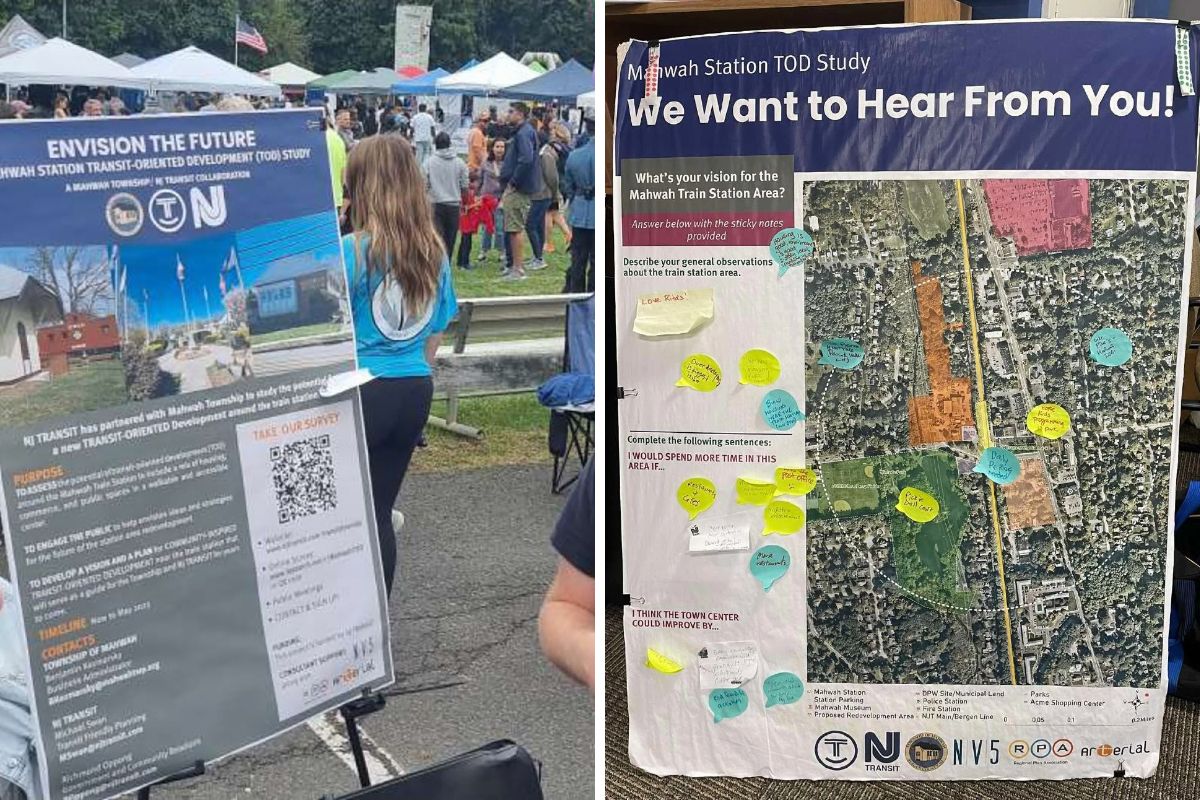
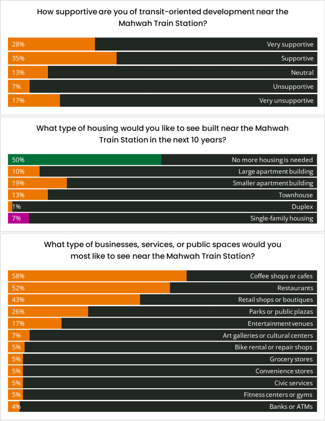
Overall, the community expressed interest in creating a more active and welcoming district around the station, though opinions varied regarding residential development. Retail, dining, and community amenities, including indoor community space, received broad support, while housing generated mixed reactions. Although half of respondents indicated they did not want additional housing near the station, 43 percent supported some form of multifamily development.
These conversations helped the study team identify opportunities that respond to local priorities while remaining sensitive to the character of the surrounding neighborhood.
Creating Safe, Vibrant Streets
A station only functions as a community hub when people can easily and safely get to it. In Mahwah, however, much of the area surrounding the station is designed primarily for cars. Gaps in the sidewalk network and the lack of bicycle infrastructure make it difficult for residents to comfortably walk or bike between the station, nearby neighborhoods, and local destinations.
The study recommends a complete streets approach that would improve safety and accessibility for all road users (NJ TRANSIT, 2025). Proposed pedestrian, bicycle, and circulation improvements would strengthen connections between the station, surrounding neighborhoods, and key destinations throughout the study area. Better links between the station and the area’s three parks could also help maximize the value of these public spaces and encourage more walking and cycling.

Beyond mobility improvements, the study envisions a stronger sense of place around the station. Streetscape enhancements such as wayfinding, pedestrian-scale lighting, street trees, and a consistent materials palette could create a more welcoming and walkable environment while giving the district a distinct identity.
The station itself could also serve as a mobility hub, with amenities such as bicycle storage, improved bus and shuttle stops, and designated pick-up and drop-off areas that make it easier to connect between different modes of travel.

Promoting Transit-Friendly Land Use
Improving streets, public spaces, and transportation options is only part of the equation. The study also explores how redevelopment near the station could support Mahwah’s evolving housing needs while bringing new activity and amenities to the area.
The station area is characterized by relatively low-intensity uses, with single-family housing accounting for more than half of the 328 housing units located within a quarter mile of the station (NJ TRANSIT, 2025). The study examines how strategic redevelopment and targeted land use changes could introduce a broader mix of housing types while preserving the township’s open spaces and established character.
Redevelopment
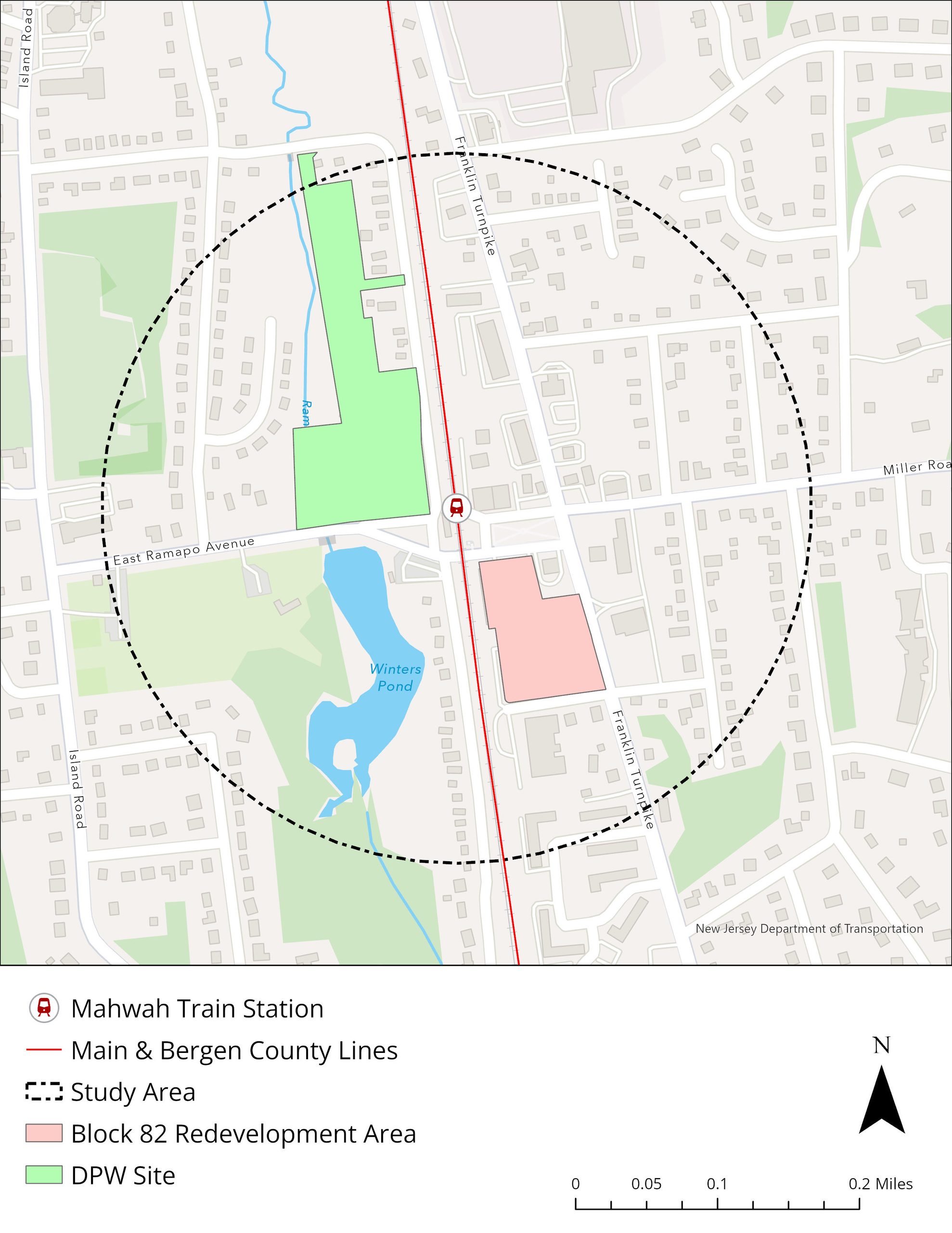
The study identified several underutilized properties that could help accommodate future growth near the station. Strategic redevelopment could bring new housing, support local businesses, and help create a more active station area while making use of land that is already developed.
Mahwah’s Fair Share Housing Plan projects 62 new housing units to be built in the study area by 2035 (Colliers Engineering & Design, 2026a). Most are expected to come from the Block 82 Redevelopment, an already designated redevelopment area located southeast of the station.
In addition to Block 82, the study identified a township-owned site northwest of the station as a longer-term opportunity. The 8.5-acre site currently houses Mahwah’s Department of Public Works (DPW) facility, which is expected to be relocated, along with a parking lot, the Old Mahwah Station Museum, and the public recycling center (NJ TRANSIT, 2025).
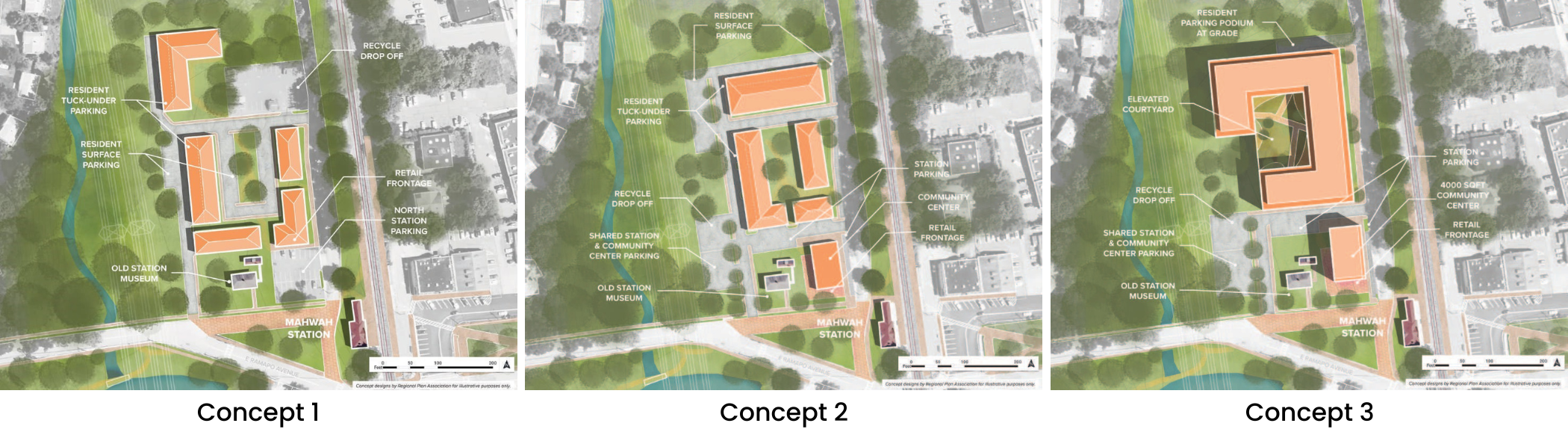
To explore possibilities for the site, the study outlined four redevelopment concepts that balance existing services with new residential, retail, and community uses. Depending on the development scenario, redevelopment of the DPW site could generate up to $2.6 million in local tax revenue.
Concept 1 includes 46 two-story stacked townhouses and 2,400 sq. ft. of retail space while retaining the site’s existing improvements.
Concept 2 includes 87 residential units in five 3.5-story buildings, including one mixed-use building with 2,400 sq. ft. of retail space and a 3,000-sq.-ft. community center. The station parking lot and recycling center would be reconfigured to accommodate the new development.
Concept 3A and Concept 3B represent more intensive development scenarios. Concept 3A includes 125 residential units in a five-story building, while Concept 3B has 188 units in a seven-story building. Both concepts feature a mixed-use building containing 2,400 sq. ft. of retail space and a 4,000-sq.-ft. community center, along with reconfigured station parking and recycling facilities.
Zoning and Land Use Policy
In addition to encouraging redevelopment opportunities, the study also outlines several planning tools that could support future investment around the station (NJ TRANSIT, 2025).
A TOD overlay zone could allow a broader mix of residential (medium- and high-density), retail, and commercial uses near the station while establishing design standards that support a walkable and cohesive district. The overlay zone could also include more flexible minimum lot-size and parking requirements tailored to a transit-served area.
The study also recommends exploring designation of the DPW property as an Area in Need of Redevelopment. This designation would allow the Township to adopt a redevelopment plan and access financing tools, such as payment-in-lieu-of-taxes (PILOT) agreements that can help make redevelopment projects more feasible.
Another potential strategy is pursuing Highlands Center designation for the study area. By directing growth toward an area already served by infrastructure and transit, Highlands Center designation can support redevelopment while protecting natural resources and environmentally sensitive lands elsewhere in the municipality.
Related Planning Efforts
The study’s recommendations build upon planning initiatives already underway at the municipal, county, and regional levels.
Recent amendments to Mahwah’s Master Plan have added overlay zones, made allowable uses more flexible, and permitted housing development on commercial properties (Colliers Engineering & Design, 2025; 2026b; 2026c). These efforts align with many of the land use strategies identified in the TOD study.
The recommendations are also consistent with broader regional planning goals. Regionally, Bergen County’s Master Plan encourages transit-oriented, mixed-use, and brownfield redevelopment, while the Highlands Regional Master Plan supports directing growth to appropriate locations while protecting critical natural resources (Bergen County, 2023; Highlands Council, 2008). A 2024 amendment that exempted fully affordable housing developments in the Highlands region from certain restrictions may also create additional opportunities for future development in Mahwah (Highlands Council, 2024).
Moving Forward
Recent improvements show that this process is already underway. NJ TRANSIT has been making improvements at Mahwah Station that include safety upgrades, aesthetic improvements, and new bicycle amenities such as bike racks (Harrington, 2025).
The Mahwah Station TOD Study provides a framework for how the township can respond to changing housing, mobility, and economic needs while preserving the natural and community assets that residents value. Rather than proposing large-scale transformation, the study focuses on targeted investments that could strengthen the station area as a destination and community gathering place.
Today, by improving connections to the station, creating opportunities for housing and redevelopment, and investing in public spaces, Mahwah has an opportunity to build on its existing assets while making it easier for residents to travel, gather, and access the region. Together, these recommendations present a vision for how Mahwah Station could evolve from primarily a commuter stop into a more active and connected center of community life.
Explore the Mahwah Station TOD Study Story Map
View interactive maps, recommendations, and implementation strategies developed through NJ TRANSIT’s Transit Friendly Planning Program.
Sources
Bergen County. (2023). Bergen County Master Plan. https://bergencountynj.gov/bergen-county-department-of-planning-engineering/bergen-county-master-plan/
Colliers Engineering & Design. (2025, October). 2025 Amendment to the 2013 Master Plan & to the 2020 Reexamination & Master Plan Amendment. Township of Mahwah. https://www.mahwahtwp.org/ArchiveCenter/ViewFile/Item/165
Colliers Engineering & Design. (2026a, February 12). Amended 2025 Housing Element & Fair Share Plan. Township of Mahwah. https://www.mahwahtwp.org/ArchiveCenter/ViewFile/Item/174
Colliers Engineering & Design. (2026b, February 12). 2026 Master Plan & Development Regulations Reexamination. Township of Mahwah. https://www.mahwahtwp.org/ArchiveCenter/ViewFile/Item/177
Colliers Engineering & Design. (2026c, February 18). Redevelopment Plan for Block 82, Lots 1 and 3 through 30. Township of Mahwah. https://www.mahwahtwp.org/DocumentCenter/View/9106/260218-Redevelopment-Plan-for-Block-82-Lots-1-3-30-Amendment-No-3-FINAL
Harrington, J. (2025, November 7). NJ Transit Makes Exterior Renovations at Mahwah Station. ROI-NJ. https://www.roi-nj.com/2025/11/07/transportation/nj-transit-makes-exterior-renovations-at-mahwah-station/
New Jersey Highlands Water Protection and Planning Council (Highlands Council). (2008). Highlands Regional Master Plan. https://www.nj.gov/njhighlands/planning/rmp/highlands_rmp_web.pdf
New Jersey Highlands Water Protection and Planning Council (Highlands Council). (2024, July). Highlands Affordable Housing RMP Amendment. https://www.nj.gov/njhighlands/planning/rmp/amendments/amendment_pdfs/ah_amend_2024.pdf
NJ TRANSIT. (2022, September). Transit Friendly Planning: A Guide for New Jersey Communities. https://njtransit.maps.arcgis.com/sharing/rest/content/items/fe276f21feb74c09824064ce5ea3ba99/data
NJ TRANSIT. (2025, June). Mahwah Station TOD Study. Regional Plan Association. https://s3.us-east-1.amazonaws.com/rpa-org/pdfs/FINAL-Mahwah-TOD-Final-PlanAppdx-V9-6.23.2025_compressed.pdf
Township of Mahwah. (n.d.). Transportation. https://www.mahwahtwp.org/266/Transportation
U.S. Census Bureau. (n.d.). ACS Demographic and Housing Estimates. American Community Survey, ACS 5-Year Estimates Data Profiles, Table DP05. https://data.census.gov/table/ACSDP5Y2024.DP05?g=060XX00US3400342750&moe=false
U.S. Census Bureau. (n.d.). Means of Transportation to Work. American Community Survey, ACS 5-Year Estimates Detailed Tables, Table B08301. https://data.census.gov/table/ACSDT5Y2024.B08301?t=Commuting&g=060XX00US3400342750&moe=false